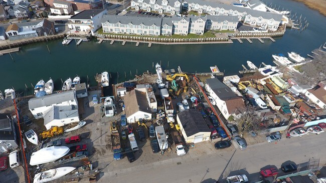
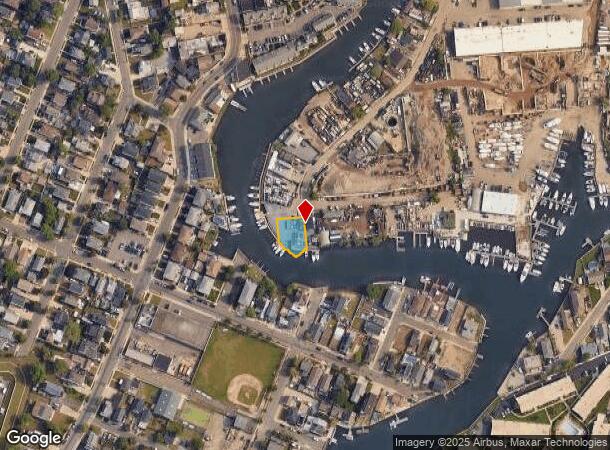
Property Record
66 New St, Oceanside, NY 11572
NEARBY LISTINGS FOR SALE OR LEASE
Property Detail
66 New St
2005-43-301-00-0104-A
LOTS 104A,104B TOWN #1 SCH DIST 011
Marinafacility
Nassau
AE
New York
36059C0218G
104
2025
0.16 AC
2025
Southern Nassau
413002
Long Island (New York)
371 SF
Nassau County-Suffolk County, NY
DEMOGRAPHICS near 66 New St
1 Mile
3 Mile
5 Mile
2024 Total Population
21,460
159,949
460,659
2029 Population
21,086
156,956
448,721
Pop Growth 2024-2029
(1.74%)
(1.87%)
(2.59%)
Average Age
42
42
41
2024 Total Households
7,669
55,080
149,731
HH Growth 2024-2029
(1.93%)
(2.01%)
(2.65%)
Median Household Inc
$113,350
$123,818
$117,265
Avg Household Size
2.70
2.80
2.90
2024 Avg HH Vehicles
2.00
2.00
2.00
Median Home Value
$630,178
$660,457
$624,373
Median Year Built
1954
1952
1953
Nearby Places
- Restaurants
- Banks
- Shops
- Fitness
- Groceries
PUBLIC TRANSPORTATION
COMMUTER RAIL
Oceanside Station (Long Beach Branch - Long Island Rail Road)
DRIVE
WALK
Distance
Oceanside Station (Long Beach Branch - Long Island Rail Road)
3 min
18 min
1.0 mi
East Rockaway Station (Long Beach Branch - Long Island Rail Road)
DRIVE
WALK
Distance
East Rockaway Station (Long Beach Branch - Long Island Rail Road)
4 min
1.2 mi
AIRPORT
John F Kennedy International
DRIVE
WALK
Distance
John F Kennedy International
22 min
11.0 mi
LaGuardia
DRIVE
WALK
Distance
LaGuardia
36 min
20.5 mi
Westchester County
DRIVE
WALK
Distance
Westchester County
57 min
41.5 mi
Nearby Properties
Address
Land Use
TOTAL SIZE
Lot Size
Zoning
Address
Land Use
TOTAL SIZE
Lot Size
Zoning
64,618 SF
8.04 AC
Address
Land Use
TOTAL SIZE
Lot Size
Zoning
Address
Land Use
TOTAL SIZE
Lot Size
Zoning
Address
Land Use
TOTAL SIZE
Lot Size
Zoning
5,800 SF
10.48 AC
Address
Land Use
TOTAL SIZE
Lot Size
Zoning
88.30 AC
Address
Land Use
TOTAL SIZE
Lot Size
Zoning
350.74 AC
Address
Land Use
TOTAL SIZE
Lot Size
Zoning
336,450 SF
139.91 AC
Address
Land Use
TOTAL SIZE
Lot Size
Zoning
30,700 SF
88.36 AC
Address
Land Use
TOTAL SIZE
Lot Size
Zoning
133.85 AC
Address
Land Use
TOTAL SIZE
Lot Size
Zoning
92.92 AC
Address
Land Use
TOTAL SIZE
Lot Size
Zoning
57,970 SF
1.69 AC
Address
Land Use
TOTAL SIZE
Lot Size
Zoning
46,404 SF
38.43 AC
Address
Land Use
TOTAL SIZE
Lot Size
Zoning
227,776 SF
16.06 AC
Address
Land Use
TOTAL SIZE
Lot Size
Zoning
115.42 AC
Address
Land Use
TOTAL SIZE
Lot Size
Zoning
151,757 SF
34.38 AC
Address
Land Use
TOTAL SIZE
Lot Size
Zoning
99,904 SF
20.17 AC
Address
Land Use
TOTAL SIZE
Lot Size
Zoning
20,670 SF
6.62 AC
Address
Land Use
TOTAL SIZE
Lot Size
Zoning
357,868 SF
24.92 AC
Address
Land Use
TOTAL SIZE
Lot Size
Zoning
66.41 AC
Address
Land Use
TOTAL SIZE
Lot Size
Zoning
140,992 SF
12.07 AC
Address
Land Use
TOTAL SIZE
Lot Size
Zoning
61.52 AC
Address
Land Use
TOTAL SIZE
Lot Size
Zoning
74,813 SF
4.56 AC
Address
Land Use
TOTAL SIZE
Lot Size
Zoning
58.86 AC
Address
Land Use
TOTAL SIZE
Lot Size
Zoning
60.30 AC
Address
Land Use
TOTAL SIZE
Lot Size
Zoning
7,172 SF
0.06 AC
R6
Address
Land Use
TOTAL SIZE
Lot Size
Zoning
484,552 SF
11.56 AC
Address
Land Use
TOTAL SIZE
Lot Size
Zoning
59,715 SF
12.81 AC
Address
Land Use
TOTAL SIZE
Lot Size
Zoning
41,612 SF
3.89 AC
Address
Land Use
TOTAL SIZE
Lot Size
Zoning
37.90 AC
Address
Land Use
TOTAL SIZE
Lot Size
Zoning
45,854 SF
2.31 AC
The World's #1 Commercial Real Estate Marketplace
Connect with us
© 2025 CoStar Group
The information above has been obtained from sources believed reliable. While we do not doubt its accuracy we have not verified it and make no guarantee, warranty or representation about it. It is your responsibility to independently confirm its accuracy and completeness. Any projections, opinions, assumptions, or estimates used are for example only and do not represent the current or future performance of the property. The value of this transaction to you depends on tax and other factors which should be evaluated by your tax, financial, and legal advisors. You and your advisors should conduct a careful, independent investigation of the property to determine to your satisfaction the suitability of the property for your needs.